Light Brown Apple Moth (LBAM)
Regulation and Quarantine Boundaries

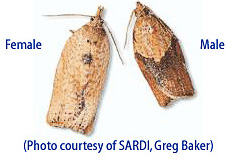
LBAM has been associated with many plants representing 290 genera (USDA 2008). These genera contain over 2000 species and many of these species that are not already known to be hosts could prove to be hosts as LBAM becomes exposed to them.
Information
Map Overview
Options available for viewing maps:
- Map Index: Links to maps covering northern area, central area, southern area and entire state. Also provided are the overall regulated area layer map (Google Earth) and the regulated area web map (Zoomable Map).
- State Overview: For Reference Only. This map shows all grids in entire state.
- Northern California: Click on image to open map containing grid numbers linking to specific areas in northern California. If you know the grid number of your area, click on grid number.
- Central California: Click on image to open map containing grid numbers linking to specific areas in central California. If you know the grid number of your area, click on grid number.
- Southern California: Click on image to open map containing grid numbers linking to specific areas in southern California. If you know the grid number of your area, click on grid number.
Map Index
- Grid 111
- Grid 121
- Grid 154
- Grid 155
- Grid 157
- Grid 158
- Grid 165
- Grid 166
- Grid 167
- Grid 168
- Grid 169
- Grid 176
- Grid 177
- Grid 178
- Grid 179
- Grid 180
- Grid 187
- Grid 188
- Grid 189
- Grid 190
- Grid 191
- Grid 199
- Grid 200
- Grid 201